
Dog River Park
A Floodplain and Community Space
Click here for Dog River Park featured in Marketplace from American Public Media
The story of Dog River Park is a hopeful one, in proving that a functioning floodplain substantially lessens the extent of damage in a major flooding event and can even serve as a shared community open-space. Friends of the Winooski is proud to highlight the Dog River Park project as a model of what is possible for floodplains through resilience planning, collaboration, and community involvement.
The need:
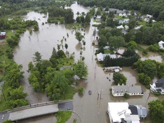
On August 28th of 2011, the small town of Northfield, Vermont was devastated by Tropical Storm Irene which flooded the Dog River. As Northfield town resident, Christine Barnes, described “[Our river] quickly swelled into angry torrents, ripping through roads, bridges and farmlands, slashing new waterways where none existed before, and drowning our community.” Irene brought over seven inches of rainfall, causing between $1-1.5 million in infrastructural damage and $2.2 million in lost property tax revenue to the Town of Northfield. Much of the damage was concentrated in the Water Street neighborhood, where the Town of Northfield bought 18 flooded homes within the floodplain through FEMA. Northfield was now the owner of a 4-acre parcel of open land along the Dog River. 
How could this open space be utilized strategically, sustainably, and with flood resilience at the forefront of planning?
Michele Braun, in her role as the planner and zoning administrator for the Town of Northfield, asked Ann Smith, Executive Director of Friends of the Winooski River, for help in doing just this. So, with the partnership of the Town and FWR, and in collaboration with SLR Consulting Engineers and GPI Landscape Architects, we began weighing the possibilities of what this land could be. We listened to input from the community and from experts in flood mitigation, carefully considering all possible outcomes.
 The Project:
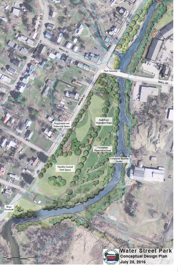
Looking at an aerial map of the river and the neighborhood, the river is aimed directly towards the densely-settled area of about 80 homes between Water Street and Pleasant Street. We wondered whether there was an opportunity to use the land in a way that would reduce flood risk in the neighborhood. If so, we could potentially make the neighborhood more affordable by lowering flood insurance costs and the costs associated with future flooding events, and in doing so, creating a safer place for homes and residents. The idea of a park came into view.
Michele reached out to an architecture class at Norwich University in the Fall of 2017 to invite them to be involved in the design of a potential river-front park. Her vision was that the park would be multipurpose: a functioning floodplain, a public open-space, and an educational tool. The class divided into groups to produce three conceptual landscape designs and presented them to a selection board. This, Michele says, brought excitement to the community. There was now a visual representation for what this space could look like. A few of the students involved with the designs had lost their own homes to the flood, and wanted the open-space to be used intentionally in the place where their homes once stood, making the case for the park even more profound.
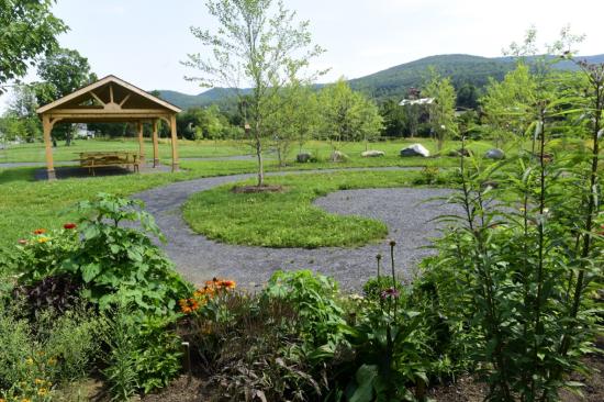
The last property buyout closed March 30, 2015 with demolition soon to follow. Then, after years of planning and collaboration between The Town of Northfield, Friends of the Winooski, Two Rivers Ottauquechee Regional Planning Commission, water resource engineers at Milone & MacBroom (now SLR), US Fish and Wildlife, the Mad/Dog Chapter of Trout Unlimited, the Winooski Natural Resources Conservation District, Norwich University, the Northfield Conservation Commission, and residents of the Water Street neighborhood – Dog River Park was completed in 2017! With a pollinator garden, walking paths and river access points, the park welcomes residents and visitors to enjoy a scenic stroll by the river while also learning about the function of the floodplain beneath their feet.
The park is specifically designed to flood and to recover from flooding without needing major repairs. It includes three distinct zones: a lawn along Water Street, a big wildflower meadow in the middle, and native trees and shrubs that line the river as a riparian buffer.
The Test of Time:
Since its completion in 2017, Dog River Park has experienced quite a few floods that have filled the meadow and spread into the lawn, and it has performed just as designed. Excess water is temporarily stored, diverted from homes, and gradually released. Woody debris is also caught by the trees and shrubs of the riparian buffer along the water's edge. Then, in July of 2023, the Water Street neighborhood was inundated by a nearly-50-year flood event. Although the park is not large enough to store this magnitude of water, a study was conducted by the engineers to determine that the depth of water across the neighborhood was six inches lower than it would have been without the park in place. This may not seem like much, but it’s the difference between homes experiencing basement-only flooding and additional first floor damage, which is major.
Dog River Park stands the test of time (and high waters), and will continue to serve as a model for floodplain management across Vermont. Friends of the Winooski River takes great pride in this project and continues to seek more opportunities to restore floodplains that allow our rivers to spread out and slow down in high rainfall events, while protecting all communities of the Winooski watershed.